Jasper National Park Scenic Drives
Jasper National Park scenic drives mean you don’t need to travel deep into the backcountry to view the most spectacular features—many are visible from the roadside. The following section includes one of the world’s most scenic highways, the Icefields Parkway.
Icefields Parkway
This section of text describes worthwhile stops from south to north, beginning at the Columbia Icefield and ending at the town of Jasper. We also have a section of this website devoted to the entire Icefields Parkway. Also recommended is the book Icefields Parkway: One of the World’s Most Scenic Drives, which is available directly from the publisher and also all lodges and gift shops along the route.
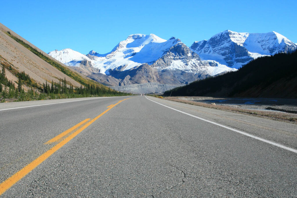
Icefields Parkway near Columbia Icefield.
Sunwapta Pass (2,040 metres/6,690 feet), four kilometres (2.5 miles) south of the Icefield Centre, marks the boundary between Banff and Jasper National Parks.
The following sights along the Icefields Parkway are detailed from south to north, from the Icefield Centre to the town of Jasper, a distance of 105 kilometres (65 miles). The scenery along this stretch of road is no less spectacular than the other half through Banff National Park, and it’s easy to spend at least a full day en route.
No gas is available along this stretch of the Icefields Parkway. The nearest gas stations are at Saskatchewan River Crossing (Banff National Park) and in the town of Jasper, 150 kilometres (93 miles) apart, so keep your tank topped up to be safe.
Columbia Icefield
The Columbia Icefield is the largest and most accessible of 17 glacial areas along the Icefields Parkway. For northbound Icefield Parkway travellers, it will be the first stop. Overlooking the Athabasca Glacier, an arm of the Columbia Icefield, is the ICEFIELD CENTRE (May to early Oct.). This is the starting point for bus tours onto the glacier, and the facility also has interpretive displays, a gift shop, cafes, a restaurant, and guest rooms. For more details on everything there is to see and do in the area, visit our Columbia Icefield page, or the Columbia Icefield Hiking page.
Columbia Icefield Skywalk
The architecturally impressive Columbia Icefield Skywalk projects out into the Sunwapta Canyon 280 metres (918 feet) above the valley floor. Access is by shuttle bus from the Icefield Centre (no passenger vehicles are allowed to stop), from where a short interpretive trail leads along the canyon edge and then out onto the glass-floored skywalk. Looking upstream from the skywalk, you can see the massive, ice-draped slopes of Mount Athabasca (3,491 m/ 11,450 ft) framed by the walls of the valley—a truly inspiring view of this great mountain. Directly across the valley is the ice-capped east face of Mount Kitchener. The Glacier Skywalk is operated by Pursuit May through October. Tours depart from the Icefield Centre daily between 9 a.m. and 6 p.m.
From the Skywalk, northbound travellers lose 300 metres (980 ft) of elevation over the next four km (2.5 miles), descending to the floor of the Sunwapta Valley.
Sunwapta Falls
A further 41 kilometres (25 miles) along the Icefields Parkway a 500-metre (0.3-mile) spur at Sunwapta Falls Resort leads to Sunwapta Falls. Here the Sunwapta River changes direction sharply and drops into a deep canyon. The best viewpoint is from the bridge across the river, but it’s also worth following the path on the parking lot side of the river downstream along the rim of the canyon. Two kilometres (1.2 miles) downstream the river flows into the much-wider Athabasca Valley at the Lower Falls.
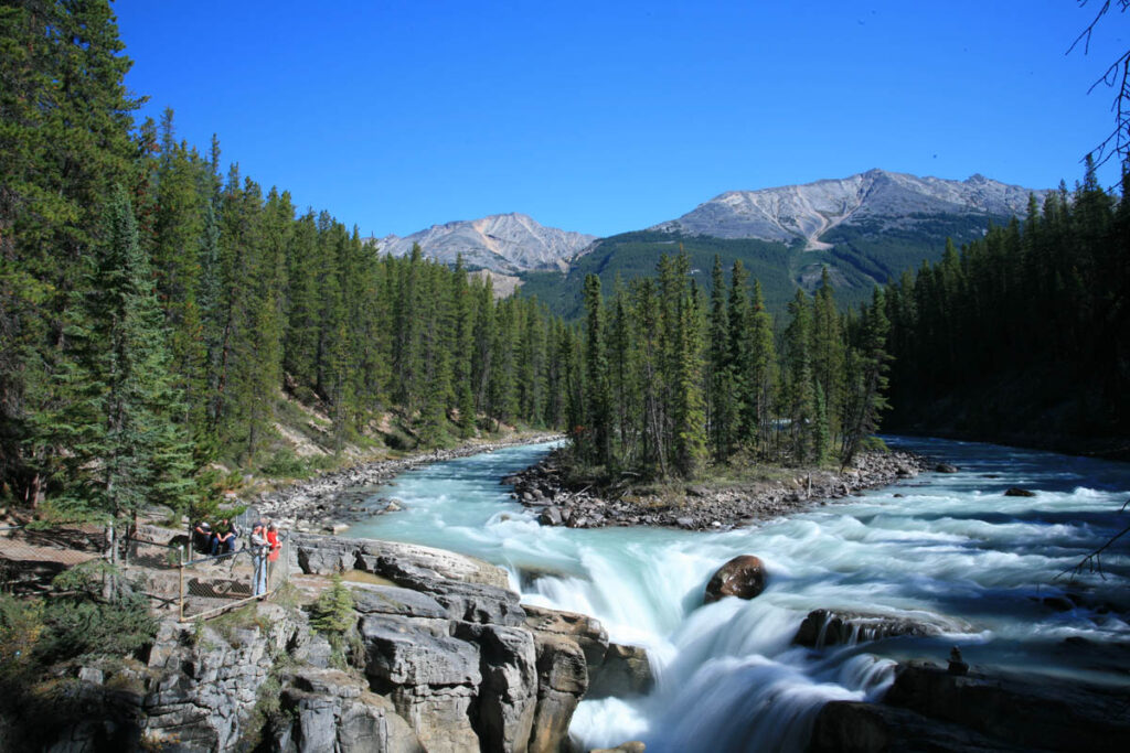
Sunwapta Falls
Goats and Glaciers Lookout
After following the Athabasca River for 17 kilometres (11 miles), the road ascends to a lookout with picnic tables offering panoramic river views. Below the lookout is a steep bank of exposed glacially ground material containing natural deposits of salt. The local mountain goats spend most of their time on the steep slopes of Mount Kerkeslin, to the northeast, but occasionally cross the road and can be seen searching for the salt licks along the roadside or riverbank, trying to replenish lost nutrients.
Athabasca Falls
Nine kilometres (5.6 miles) beyond Goat Lookout and 32 kilometres (20 miles) south of Jasper, the Icefields Parkway divides when an old stretch of highway (Highway 93A) crosses the Athabasca River and continues along its west side for 25 kilometres (15.5 miles) before rejoining the parkway seven kilometres (4.3 miles) south of the town. At the southern end of this loop, the Athabasca River is forced through a narrow gorge and over a cliff into a cauldron of roaring water below. As the river slowly erodes the centre of the riverbed, the falls will move upstream. Trails lead from a day-use area to various viewpoints above and below the falls. The trail branching under Highway 93A follows an abandoned river channel before emerging at the bottom of the canyon. Facilities at Athabasca Falls include picnic tables and washrooms.
Continuing North to Jasper
Take Highway 93A beyond Athabasca Falls to reach Mount Edith Cavell, or continue north along the Icefields Parkway to access the following sights. The first worthwhile stop along this route is Horseshoe Lake, reached along a 350-metre (0.2-mile) trail from a parking lot three kilometres (1.9 miles) north of Athabasca Falls. The southern end of this delightful little body of water is ringed by a band of cliffs (popular with locals in summer as a cliff-diving spot), but many private (unofficial) picnic spots line its western shoreline.
Two kilometres (1.2 miles) north of the Horseshoe Lake parking lot are a couple of lookouts with sweeping views across the Athabasca River to Athabasca Pass, used by David Thompson on his historic expedition across the continent. To the north of the pass lies Mount Edith Cavell. From this lookout it is 26 kilometres (16 miles) to the town of Jasper.
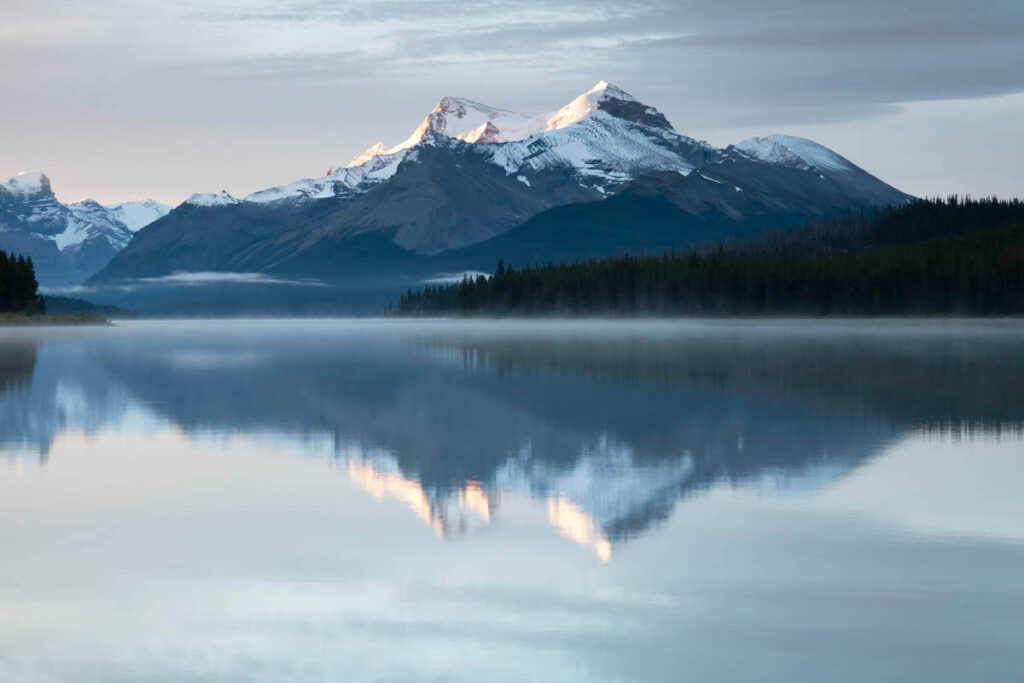
Maligne Valley Road
This 48-kilometre (30-mile) road leads south from just east of the town of Jasper to Maligne Lake, passing the following attractions.
Maligne Canyon
Maligne Lake, one of the world’s most photographed lakes, lies 48 kilometres (30 miles) southeast of Jasper. It’s the source of the Maligne River, which flows northward to Medicine Lake and then disappears underground, eventually emerging downstream of Maligne Canyon. The river was known to the natives as Chaba Imne (River of the Great Beaver), but the name by which we know it today was coined by a missionary. After his horses were swept away by its swift-flowing waters in 1846, he described the river as being “la traverse maligne.” Driving up the Maligne River Valley to the lake is a 600-million-year-old lesson in geology that can be appreciated by anyone.
As the Maligne River drops into the Athabasca River Valley, its gradient is particularly steep. The fast-flowing water has eroded a deep canyon out of the easily dissolved limestone bedrock. The canyon is up to 50 metres (165 feet) deep, yet so narrow that squirrels often jump across. At the top of the canyon, opposite the teahouse, you’ll see large potholes in the riverbed. These potholes are created when rocks and pebbles become trapped in what begins as a shallow depression; under the force of the rushing water, they carve jug-shaped hollows into the soft bedrock.
To get here, head northeast from town and turn right onto Maligne Lake Road. The canyon access road veers left 11 kilometres (6.8 miles) from Jasper.
An interpretive trail winds down from the parking lot, crossing the canyon six times. The most spectacular sections of the canyon can be seen from the first two bridges, at the upper end of the trail. In summer a teahouse operates at the top of the canyon. To avoid the crowds at the upper end of the canyon, an alternative would be to park at Sixth Bridge, near the confluence of the Maligne and Athabasca Rivers, and walk up the canyon.
Medicine Lake
From the canyon, Maligne Lake Road climbs to Medicine Lake, which does a disappearing act each year. The water level fluctuates due to a network of underground passages that emerge downstream in Maligne Canyon. At the northwest end of the lake, beyond where the outlet should be, the riverbed is often dry. In fall, when runoff from the mountains is minimal, the water level drops, and by November the lake comprises a few shallow pools. Natives believed that spirits were responsible for the phenomenon, hence the name.
Maligne Lake
At the end of the road, 48 kilometres (30 miles) from town, is Maligne Lake, the largest glacier-fed lake in the Canadian Rockies and second largest in the world. The first paying visitors were brought to the lake in the 1920s, and it has been a mecca for camera-toting tourists from around the world ever since. Once at the lake, activities are plentiful. But other than taking in the spectacular vistas, the only thing you won’t need your wallet for is hiking one of the numerous trails in the area.
For details visit our Maligne Lake pages.
Maligne Lake
Cavell Road
Mount Edith Cavell, at 3,363 metres (11,033 feet), is the most distinctive and impressive in Jasper National Park. Known to First Nations as the “White Ghost” for its snowcapped summit, the mountain was given its official name in honor of a British nurse who was executed for helping prisoners of war escape German-occupied Belgium during World War I. The peak was first climbed that same year; today the most popular route to the summit is up the east ridge (to the left of the summit). The imposing north face (facing the parking lot) has been climbed but is rated as an extremely difficult climb.
For those less adventurous, several vantage points, including downtown Jasper and the golf course, provide good views of the peak. But the most impressive place to marvel at the mountain is from directly below the north face. The 14.5-kilometre (nine-mile) Cavell Road winds up the Astoria River Valley from Highway 93A, ending right below the face. This steep, narrow road has many switchbacks. Trailers must be left in the designated area at the bottom. Highway 93A was the original Icefields Parkway, following the southeast bank of the Athabasca River. The route has now been bypassed by the more direct one on the other side of the river.
From the parking lot at the end of the road, you must strain your neck to take in the magnificent sight of the mountain’s 1,500-metre (4,920-foot) north face and Angel Glacier, which lies in a saddle on the mountain’s lower slopes. On warm days, those who are patient may be lucky enough to witness an avalanche tumbling from the glacier, creating a roar that echoes across the valley. From the parking area, the Path of the Glacier Trail (one hour round-trip) traverses barren moraines deposited by the receding Angel Glacier and leads to some great viewpoints.
East Along Highway 16 from the Town of Jasper
From Jasper, it’s 50 kilometres (31 miles) to Jasper National Park’s eastern boundary along Highway 16, following the Athabasca River the entire way. Beyond the turnoff to Maligne Lake, Highway 16 enters a wide valley flanked to the west by The Palisade and to the east by the Colin Range. The valley is a classic montane environment, with open meadows and forests of Douglas fir and lodgepole pine. After crossing the Athabasca River, 20 kilometres (12 miles) from Jasper, the highway parallels Jasper Lake, which is lined by sand dunes along its southern edge. At the highway, a plaque marks the site of Jasper House (the actual site is on the opposite side of the river). The next worthwhile stop is Disaster Point, four kilometres (2.5 miles) farther north. This is a great spot for viewing bighorn sheep, which gather at a mineral lick, an area of exposed mineral salts. Disaster Point is on the lower slopes of Roche Miette, a distinctive 2,316-metre-high (7,600-foot-high) peak that juts out into the Athabasca River Valley. Across the highway, the braided Athabasca River is flanked by wetlands alive with migrating birds spring and fall.
Miette Hot Springs Road branches south from the highway 43 kilometres (27 miles) east of Jasper. This junction marks the site of Pocahontas, a coal-mining town in existence between 1910 and 1921. The mine itself was high above the township, with coal transported to the valley floor by cable car. All buildings have long since been removed, but a short interpretive walk leads through the remaining foundations. One kilometre (0.6 mile) along Miette Hot Springs Road, a short trail leads to photogenic Punchbowl Falls. Here Mountain Creek cascades through a narrow crevice in a cliff to a pool of turbulent water.
Miette Hot Springs
After curving, swerving, rising, and falling many times, Miette Hot Springs Road ends 18 kilometres (11 miles) from Highway 16 at Miette Hot Springs, the warmest springs in the Canadian Rockies. They are open mid-May to mid-October. In the early 1900s, these springs were one of Jasper National Park’s biggest attractions. In 1910, a packhorse trail was built up the valley, and the government constructed a bathhouse. The original hand-hewn log structure was replaced in the 1930s with pools that remained in use until new facilities were built in 1985. Water that flows into the pools is artificially cooled from 54°C (128°F) to a soothing 39°C (100°F). A newer addition to the complex is a smaller, cool plunge pool.
Many hiking trails begin from the hot springs complex; the shortest is from the picnic area to the source of the springs (allow five minutes each way). Overlooking the pools is a cafe, while a restaurant and lodging are just down the hill.
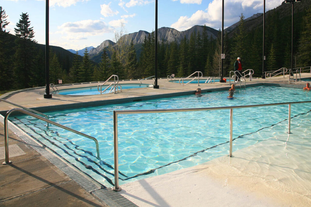
Miette Hot Springs