Icefields Parkway Driving Guide
This Icefields Parkway Driving Guide describes the 230-kilometre (143-mile) Icefields Parkway, between Lake Louise and Jasper, one of the most scenic, exciting, and inspiring mountain roads ever built.
For a PDF version, visit our Icefields Parkway Driving Guide Book page.
From Lake Louise the Icefields Parkway parallels the Continental Divide, following in the shadow of the highest, most rugged mountains in the Canadian Rockies. The first 122 kilometres (76 miles) to Sunwapta Pass (the boundary between Banff and Jasper National Parks) can be driven in two hours, and the entire parkway in four hours. But it’s likely you’ll want to spend at least a day, probably more, stopping at each of the 13 viewpoints, hiking the trails, watching the abundant wildlife, and just generally enjoying one of the world’s most magnificent landscapes. Along the section within Banff National Park are two lodges, three hostels, three campgrounds, and one gas station (summer only).
Although the road is steep and winding in places, it has a wide shoulder, making it ideal for an extended bike trip. Allow seven days to pedal north from Banff to Jasper, staying at hostels or camping along the route. This is the preferable direction to travel by bike because the elevation at the town of Jasper is more than 500 metres (1,640 feet) lower than either Banff or Lake Louise.
The Icefields Parkway remains open year-round, although winter brings with it some special considerations. The road is often closed for short periods for avalanche control; check road conditions in Banff or Lake Louise before setting out. And be sure to fill up with gas; no services are available between November and April.
How Long Does it Take to Drive the Icefields Parkway?
The question of how long it take to drive the Icefields Parkway depends on many factors. For most of the route, the maximum speed limit is 90 km/hour (56 miles/hour), but there are sections where the speed limit drops to 60 km/hour (37 miles hour).
If you set out early in the morning, before most other travellers, you can drive the route in around three hours. If you leave either Lake Louise or Jasper after 9 am June through September, traffic will slow your journey down considerably, and you can expect the trip to take four to five hours (without stops).
One-day Icefields Parkway Itinerary
For most travellers, an Icefields Parkway itinerary will include many stops. If you have one full day, we recommend stops at Bow Lake, Bow Summit, Lower Waterfowl Lake, the Columbia Icefield, Tangle Falls, and either Sunwapta or Athabasca Falls. This still allows time for an Ice Explorer excursion and a stop for picnic lunch enroute (pick this up at Laggans Bakery in Lake Louise of Bear’s Paw Bakery in Jasper). During the long days of early summer, you will also have time for Icefields Parkway hiking, such as to Wilcox Pass or Chephren Lake.
Two-day Icefields Parkway Itinerary
Two days is an ideal Icefields Parkway itinerary. This will give you enough time to take in all the stops of the One Day Icefields Itinerary, above, as well as extra stops and at least two hikes. Chephren Lake and Wilcox Pass are two relatively easy hikes with big rewards or swap out Chephren Lake for Helen Lake if you’d like more of a challenge. You should also have time to reach Valley of the Five Lakes, near the town of Jasper. A two-day itinerary can either be a return trip, overnighting in Jasper or Lake Louise before making the return journey to your starting point, or you can camp or stay at an Icefields Parkway hotel along the way.
Icefields Parkway in Winter
In winter, travel is much slower than in summer. When the Icefields Parkway is snow-covered, it can take four to five hours to travel between Lake Louise and Jasper, without stops.
Between November and April, there are no services along the Icefields Parkway, so make sure you gas up, have food and water packed, and pack winter clothing and emergency supplies such as blankets.
Lake Louise to Crowfoot Glacier
The Icefields Parkway forks right from the TransCanada Highway just north of Lake Louise. The impressive scenery begins immediately. Just three kilometres (1.9 miles) from the junction is HERBERT LAKE, formed during the last ice age when retreating glaciers deposited a pile of rubble—known as a moraine—across a shallow valley and water filled in behind it. The lake is a perfect place for early-morning or early-evening photography when the Waputik Range and distinctively shaped Mount Temple are reflected in its waters.
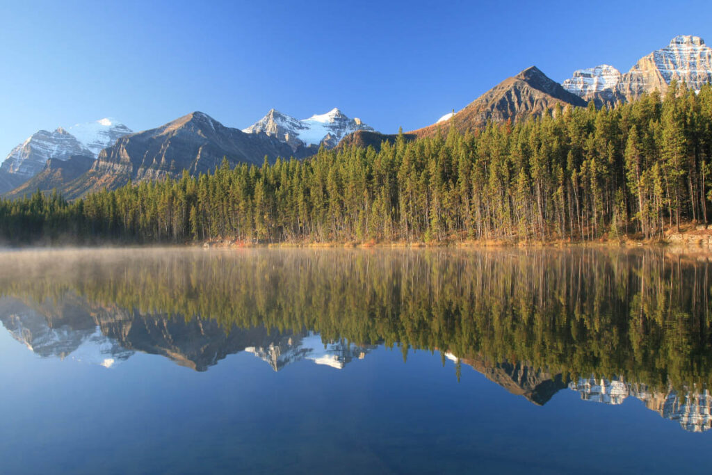
Herbert Lake is the first worthwhile stop for northbound travellers.
Travelling north, you’ll notice numerous depressions in the steep, shaded slopes of the Waputik Range across the Bow Valley. The cooler climate on these north-facing slopes makes them prone to glaciation. Cirques were cut by small local glaciers. On the opposite side of the road, MOUNT HECTOR (3,394 metres/11,130 feet), easily recognized by its layered peak, soon comes into view.
HECTOR LAKE VIEWPOINT is 16 kilometres (10 miles) from the junction. Although the view is partially obscured by trees, the emerald green waters nestled below a massive wall of limestone form a breathtaking scene. Bow Peak, seen looking northward along the highway, is only 2,868 metres (9,410 feet) high but is completely detached from the Waputik Range, making it a popular destination for climbers. As you leave this viewpoint, look across the northeast end of Hector Lake for glimpses of Mount Balfour (3,246 metres/10,650 feet) on the distant skyline.
Crowfoot Glacier
The aptly named Crowfoot Glacier can best be appreciated from a viewpoint 17 kilometres (10.6 miles) north of Hector Lake. The glacier sits on a wide ledge near the top of Crowfoot Mountain, from where its glacial claws cling to the mountain’s steep slopes. The retreat of this glacier has been dramatic. Only 50 years ago, two of the claws extended to the base of the lower cliff. Today, they are a shadow of their former selves, barely reaching over the cliff edge.
Bow Lake
The sparkling, translucent waters of Bow Lake are among the most beautiful that can be seen from the Icefields Parkway. The lake was created when moraines deposited by retreating glaciers dammed subsequent meltwater. On still days, the water reflects the snowy peaks, their sheer cliffs, and the scree slopes that run into the lake. You don’t need photography experience to take good pictures here! At the southeast end of the lake, a day-use area offers waterfront picnic tables and a trail to a swampy area at the lake’s outlet. At the upper end of the lake, you’ll find the historic Lodge at Bow Lake and the trailhead for a walk to Bow Glacier Falls.
The road leaves Bow Lake and climbs to Bow Summit. As you look back toward the lake, its true colour becomes apparent, and the Crowfoot Glacier reveals its unique shape. At an elevation of 2,069 metres (6,790 feet), this pass is one of the highest points crossed by a public road in Canada. It is also the beginning of the Bow River, the one you camped beside at Lake Louise, photographed flowing through the town of Banff and fished along downstream of Canmore.
Peyto Lake
From the parking lot at BOW SUMMIT, a paved trail leads to one of the most breathtaking views you could ever imagine. Far below the viewpoint is Peyto Lake, an impossibly intense green lake whose hues change according to season. Before heavy melting of nearby glaciers begins (in June or early July), the lake is dark blue. As summer progresses, meltwater flows across a delta and into the lake. This water is laden with finely ground particles of rock debris known as rock flour, which remains suspended in the water. It is not the mineral content of the rock flour that is responsible for the lake’s unique colour, but rather the particles reflecting the blue-green sector of the light spectrum. As the amount of suspended rock flour changes, so does the colour of the lake.
The lake is one of many park landmarks named for early outfitter Bill Peyto. In 1898, Peyto was part of an expedition camped at Bow Lake. Seeking solitude (as he was wont to do), he slipped off during the night to sleep near this lake. Other members of the party coined the name Peyto’s Lake, and it stuck.
A farther three kilometres (1.9 miles) along the parkway is a viewpoint from which PEYTO GLACIER is visible at the far end of Peyto Lake Valley. This glacier is part of the extensive Wapta Icefield, which straddles the Continental Divide and extends into the northern reaches of Yoho National Park in British Columbia.
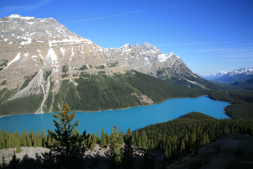
Peyto Lake.
Besides the Continental Divide
From Bow Summit, the parkway descends to a viewpoint directly across the Mistaya River from Mount Patterson (3,197 metres/10,490 feet). SNOWBIRD GLACIER clings precariously to the mountain’s steep northeast face, and the mountain’s lower, wooded slopes are heavily scarred where rock and ice slides have swept down the mountainside.
As the parkway continues to descend and crosses Silverhorn Creek, the jagged limestone peaks of the Continental Divide can be seen to the west. Mistaya Lake is a three-kilometre-long (1.9-mile-long) body of water that sits at the bottom of the valley between the road and the divide, but it can’t be seen from the Icefields Parkway. The best place to view it is from the HOWSE PEAK VIEWPOINT at Upper Waterfowl Lake. From here the high ridge that forms the Continental Divide is easily distinguishable. Seven peaks can be seen from here, including Howse Peak (3,290 metres/10,790 feet). At no point along this ridge does the elevation drop below 2,750 metres (9,000 feet). From Howse Peak, the Continental Divide makes a 90-degree turn to the west. One dominant peak that can be seen from Bow Pass to the north of Saskatchewan River Crossing is MOUNT CHEPHREN (3,268 metres/10,720 feet). Its distinctive shape and position away from the main ridge of the Continental Divide make it easy to distinguish. (Look for it directly north of Howse Peak.)
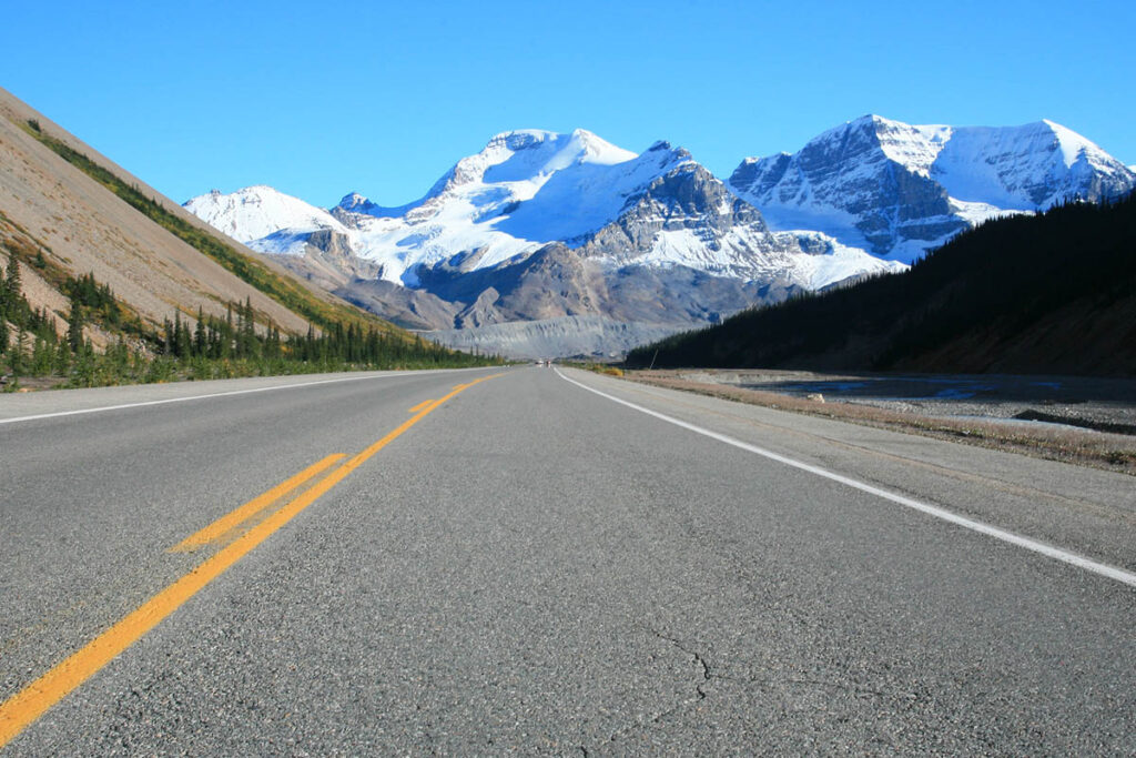
Icefields Parkway near Columbia Icefield.
To Saskatchewan River Crossing
Numerous unofficial trails lead to the swampy shores of UPPER AND LOWER WATERFOWL LAKES, providing one of the park’s best opportunities to view moose, who feed on the abundant aquatic vegetation that grows in Upper Waterfowl Lake. Rock and other debris that have been carried down nearby valley systems have built up, forming a wide alluvial fan, nearly blocking the Mistaya River and creating Upper Waterfowl Lake.
Continuing north is MOUNT MURCHISON (3,337 metres/10,950 feet), on the east side of the parkway. Although not one of the park’s highest mountains, this gray and yellow massif of Cambrian rock comprises 10 individual peaks, covering an area of 3,000 hectares (7,400 acres).
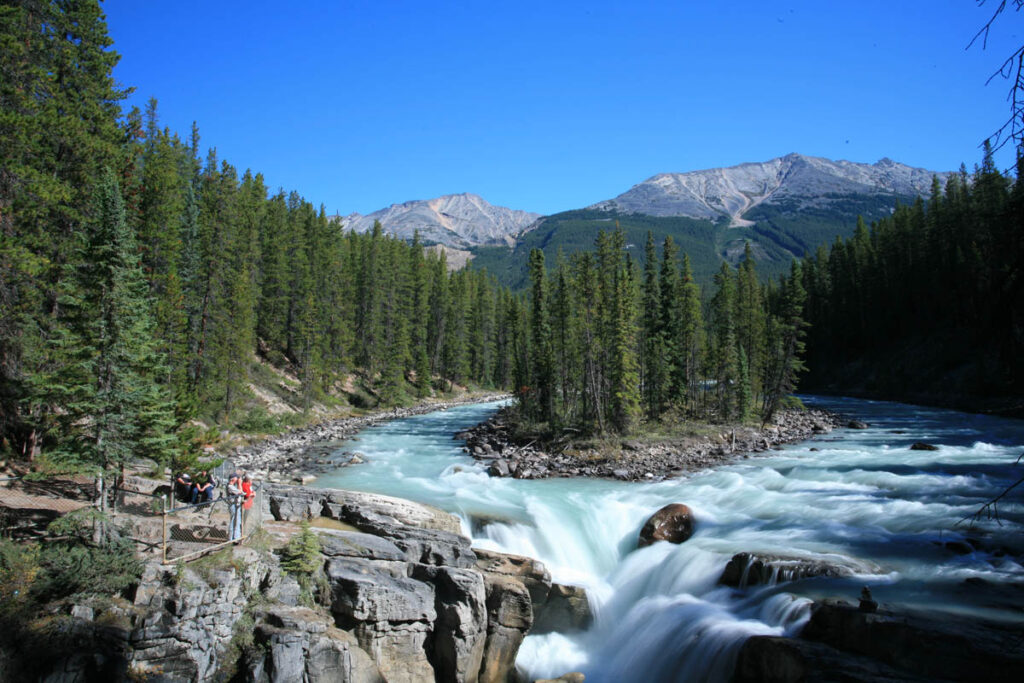
From a parking lot 14 kilometres (8.9 miles) northeast of Waterfowl Lake Campground, a short trail descends into the montane forest to MISTAYA CANYON. Here the effects of erosion can be appreciated as the Mistaya River leaves the floor of Mistaya Valley, plunging through a narrow-walled canyon into the North Saskatchewan Valley. The area is scarred with potholes where boulders have been whirled around by the action of fast-flowing water, carving deep depressions into the softer limestone bedrock below.
The NORTH SASKATCHEWAN RIVER posed a major problem for early travellers and later for the builders of the Icefields Parkway. This swiftly running river eventually drains into Hudson Bay. In 1989 it was named a Canadian Heritage River. One kilometre (0.6 mile) past the bridge you’ll come to a panoramic viewpoint of the entire valley. From here the Howse and Mistaya Rivers can be seen converging with the North Saskatchewan at a silt-laden delta. This is also a junction with Highway 11 (also known as DAVID THOMPSON HIGHWAY), which follows the North Saskatchewan River to Rocky Mountain House and Red Deer. From this viewpoint, numerous peaks can be seen to the west. Two sharp peaks are distinctive: Mount Outram (3,254 metres/10,680 feet) is the closer; the farther is Mount Forbes (3,630 metres/11,975 feet), the highest peak in Banff National Park (and the sixth highest in the Canadian Rockies).
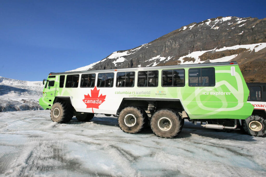
Ice Explorer on the Columbia Icefield.
To Sunwapta Pass
On the north side of the North Saskatchewan River is the towering hulk of MOUNT WILSON (3,261 metres/10,700 feet), named for Banff outfitter Tom Wilson. The Icefields Parkway passes this massif on its western flanks. A pullout just past Rampart Creek Campground offers good views of Mount Amery to the west and Mounts Sarbach, Chephren, and Murchison to the south. Beyond here is the WEEPING WALL, a long cliff of gray limestone where a series of waterfalls tumbles more than 100 metres (330 feet) down the steep slopes of Cirrus Mountain. In winter this wall of water freezes, becoming a mecca for ice climbers.
After ascending quickly, the road drops again before beginning a long climb to Sunwapta Pass. Halfway up the 360-vertical-metre (1,180-vertical-foot), climb is a viewpoint well worth a stop (cyclists will appreciate a rest). From here views extend down the valley to the slopes of Mount Saskatchewan and, on the other side of the parkway, Cirrus Mountain. Another viewpoint, farther up the road, has the added attraction of a view of Panther Falls across the valley. A cairn at Sunwapta Pass (2,023 metres/6,640 feet) marks the boundary between Banff and Jasper National Parks. It also marks the divide between the North Saskatchewan and Sunwapta Rivers, whose waters drain into the Atlantic and Arctic Oceans, respectively.
Sunwapta Falls.
Columbia Icefield
The largest and most accessible of 17 glacial areas along the Icefields Parkway is 325-square-kilometre (125-square-mile) Columbia Icefield, beside the Icefields Parkway at the south end of the park, 105 kilometres (65 miles) south from Jasper and 132 kilometres (82 miles) north from Lake Louise. It’s a remnant of the last major glaciation that covered most of Canada 20,000 years ago, and it has survived because of its elevation at 1,900 to 2,800 metres (6,230 to 9,190 feet) above sea level, cold temperatures, and heavy snowfalls.
The icefield is made more spectacular by the impressive peaks that surround it. Mount Athabasca (3,491 metres/11,450 feet) dominates the skyline, and three glaciers cling to its flanks. Dome Glacier is also visible from the highway; although part of Columbia Icefield, it is not actually connected. Instead, it is made of ice that breaks off the icefield 300 metres (980 feet) above, supplemented by large quantities of snow each winter.
For a more detailed description, visit the Columbia Icefield page. For the best hiking, visit Columbia Icefield Hiking.
Exploring the Columbia Icefield
From the Icefields Parkway, a road leads down through piles of till left by the retreating Athabasca Glacier to a parking area beside Sunwapta Lake. An interesting alternative is to leave your vehicle beside the highway and take the 1.6-kilometre (one-mile) hiking trail through the lunar-like landscape to the parking area. From this point, a short path leads up to the toe of the glacier. (Along the access road, look for the small markers showing how far the toe of the glacier reached in years past; the farthest marker is across the highway beside the stairs leading up to the Icefield Centre.)
The icefield can be dangerous for unprepared visitors. Like all glaciers, the broken surface of the Athabasca is especially hazardous because snow bridges can hide its deep crevasses. The crevasses are uncovered as the winter snows melt. The safest way to experience the glacier firsthand is on specially developed vehicles with balloon tires that can travel over the crevassed surface. These ICE EXPLORERS are operated by PURSUIT. The 90-minute tour of Athabasca Glacier includes time spent walking on the surface of the glacier. The tour operates from 9 a.m. to 5 p.m. from early May to early October (try to plan your tour for before 10 a.m. or after 3 p.m., after the tour buses have departed for the day). The ticketing office is on the main floor of the Icefield Centre, with the surrounding area resembling an airport departure lounge—check the television screens for departure times and ensure you make your way to the correct gate. Early in the season the glacier is still covered in a layer of snow and is therefore not as spectacular as during the summer.
Icefield Centre
The magnificent Icefield Centre is nestled at the base of Mount Wilcox, overlooking the Athabasca Glacier. The building is as environmentally friendly as possible: Lights work on motion sensors to reduce electricity, some water is reused, suppliers must take their packaging with them after deliveries, and the entire building freezes in winter. The Icefield Centre is open early May to early October. The rest of the year, the building is closed and there are no services or facilities.
The centre is the staging point for Ice Explorer tours, but before heading out onto the icefield, don’t miss the GLACIER GALLERY on the lower floor. This large display area details all aspects of the frozen world, including the story of glacier formation and movement. The centrepiece is a scaled-down fiberglass model of the Athabasca Glacier, which is surrounded by hands-on displays and audiovisual presentations.
Back on the main floor of the centre you’ll find a PARKS CANADA INFORMATION DESK (780/852-6288), Ice Explorer ticketing desk, a STARBUCKs café, restrooms, and the obligatory gift shop.
Upstairs you’ll find the cavernous CHALET CAFE, with snacks and hot drinks served cafeteria style and with lots of seating indoors and out. Across the hallway is ALTITUDE RESTAURANT, with a surprisingly well-priced breakfast buffet and creative dinner menu (closed for lunch)
The Icefield Centre also holds a limited number of hotel rooms in the GLACIER VIEW LODGE.
Immediately north of Icefield Centre is an unheralded pullout where few travellers stop, but which allows for an excellent panorama of the area away from the crowds. Across the glacial-green Sunwapta River is a wasteland of till and a distinctive terminal moraine left behind by the retreating Dome Glacier. Between the Dome and Athabasca Glaciers is a 3,459-metre (11,350-foot) Snow Dome.
Columbia Icefield Skywalk
The architecturally impressive Columbia Icefield Skywalk projects out into the Sunwapta Canyon 280 metres (918 feet) above the valley floor. Access is by shuttle bus from the Icefield Centre (no passenger vehicles are allowed to stop), from where a short interpretive trail leads along the canyon edge and then out onto the glass-floored skywalk. Looking upstream from the skywalk, you can see the massive, ice-draped slopes of Mount Athabasca (3,491 m/ 11,450 ft) framed by the walls of the valley—a truly inspiring view of this great mountain. Directly across the valley is the ice-capped east face of Mount Kitchener. The Columbia Icefield Skywalk is operated by Pursuit May through October. Tours depart from the Icefield Centre daily between 9 a.m. and 6 p.m.
From the Skywalk, northbound travellers lose 300 metres (980 ft) of elevation over the next four km (2.5 miles), descending to the floor of the Sunwapta Valley.
Columbia Icefield Skywalk to Jasper
A further 41 kilometres (25 miles) along the Icefields Parkway a 500-metre (0.3-mile) spur at Sunwapta Falls Resort leads to SUNWAPTA FALLS. Here the Sunwapta River changes direction sharply and drops into a deep canyon. The best viewpoint is from the bridge across the river, but it’s also worth following the path on the parking lot side of the river downstream along the rim of the canyon. Two kilometres (1.2 miles) downstream the river flows into the much-wider Athabasca Valley at the Lower Falls.
After following the Athabasca River for 17 kilometres (11 miles), the road ascends to a GOATS AND GLACIERS VIEWPOINT, a lookout with picnic tables offering panoramic river views. Below the lookout is a steep bank of exposed glacially ground material containing natural deposits of salt. The local mountain goats spend most of their time on the steep slopes of Mount Kerkeslin, to the northeast, but occasionally cross the road and can be seen searching for the salt licks along the roadside or riverbank, trying to replenish lost nutrients.
Nine kilometres (5.6 miles) beyond Goats and Glaciers Viewpoint and 32 kilometres (20 miles) south of Jasper, is ATHABASCA FALLS. Here, the Icefields Parkway divides when an old stretch of highway (Highway 93A) crosses the Athabasca River and continues along its west side for 25 kilometres (15.5 miles) before rejoining the parkway seven kilometres (4.3 miles) south of the town. At the southern end of this loop, the Athabasca River is forced through a narrow gorge and over a cliff into a cauldron of roaring water below. As the river slowly erodes the centre of the riverbed, the falls will move upstream. Trails lead from a day-use area to various viewpoints above and below the falls. The trail branching under Highway 93A follows an abandoned river channel before emerging at the bottom of the canyon. Facilities at Athabasca Falls include picnic tables and washrooms.
Continuing North to Jasper
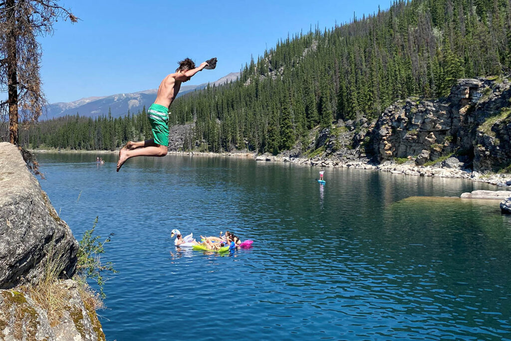
Take Highway 93A beyond Athabasca Falls to reach Mount Edith Cavell, or continue north along the Icefields Parkway to access the following sights. The first worthwhile stop along this route is HORSESHOE LAKE, reached along a 350-metre (0.2-mile) trail from a parking lot three kilometres (1.9 miles) north of Athabasca Falls. The southern end of this delightful little body of water is ringed by a band of cliffs (popular with locals in summer as a cliff-diving spot), but many private (unofficial) picnic spots line its western shoreline.
Two kilometres (1.2 miles) north of the Horseshoe Lake parking lot are a couple of lookouts with sweeping views across the Athabasca River to Athabasca Pass, used by David Thompson on his historic expedition across the continent. To the north of the pass lies Mount Edith Cavell. From this lookout, it is 26 kilometres (16 miles) to the town of Jasper.
Horseshoe Lake.