Waterton Lakes National Park Hiking
You can soak up Waterton Lakes National Park’s beauty along the scenic drives, but you’ll be cheating yourself if you don’t do any hiking in Waterton Lakes National Park. While Waterton Lakes National Park does have its fair share of uphill slogs, don’t be too daunted by the surrounding mountains—there are also some pleasant walks that everyone can enjoy, including the trail along Cameron Lake.
Although Waterton Lakes National Park is relatively small, its trail system is extensive; 224 kilometres (140 miles) of well-maintained trails lead to alpine lakes and lofty summits affording spectacular views. One of the most appealing aspects of hiking in Waterton is that with higher trailheads than other parks in the Canadian Rockies, the tree line is reached quickly. Most of the lakes can be reached in a few hours. Once you’ve finished hiking the trails in Waterton, you can cross the international border and start on the 1,200 kilometres (746 miles) of trails in Glacier National Park.
Canadian Rockies Trail Guide.
Before setting off on any hikes, whatever the length, go to Waterton Lakes Visitor Centre for trail maps, trail conditions, and trail closures, or to purchase a copy of the Canadian Rockies Trail Guide, by Brian Patton and Bart Robinson. This hiking book is also available directly from Summerthought Publishing by following this link: Canadian Rockies Trail Guide. Also available at the visitor centre is Gem Trek’s Waterton Lakes Map, which is waterproof and has details of every trail in Waterton Lakes National Park. The map is also available directly from Gem Trek: Waterton Lakes Map.
The 2017 wildfire affected all hiking trails on the west side of the village. Check http://www.pc.gc.ca/waterton for the latest trail updates.
Bear’s Hump Trail
Length: 1.2 kilometres/0.7 mile (40 minutes) one-way
Elevation gain: 225 metres/740 feet
Rating: moderate
Trailhead: Entrance Road
This is one of the most popular short hikes in Waterton Lakes National Park, and although steep, it affords panoramic views of the Waterton Valley. From the back of the small parking lot, the trail switchbacks up the northern flanks of the Bear’s Hump, through forest burnt in the 2017 wildfire, finishing at a rocky ledge high above town. From this vantage point the sweeping view extends north and east across the prairies and south along Upper Waterton Lake to Glacier National Park.
Bertha Lake Trail
Length: 5.8 kilometres/3.6 miles (2 hours) one-way
Elevation gain: 460 metres/1,510 feet
Rating: moderate
Trailhead: south side of the town site along Evergreen Avenue
Bertha Lake is a popular destination with day hikers and campers alike. For the first 1.5 kilometres (0.9 mile), moderate elevation gain is made through the burnt forest to a lookout point and the junction of the Waterton Lakeshore Trail. Then the trail branches right and level off for just over one kilometre (0.6 mile) to Lower Bertha Falls. While many casual hikers turn around at this point, you should plan on continuing to the final destination. It’s uphill all the way, as the trail crosses an old avalanche slope before switchbacking up through a subalpine forest to its maximum elevation on a ridge above the hanging valley in which Bertha Lake lies. Filtered views of Upper Bertha Falls provide an excuse for a break along the way. From the trail’s high point, it’s a short walk down to the lakeshore, from where you can continue along either shoreline or just relax under the trees with a picnic lunch. The lake itself is beautiful, both for its dark turquoise colouring and the backdrop of mountain peaks.
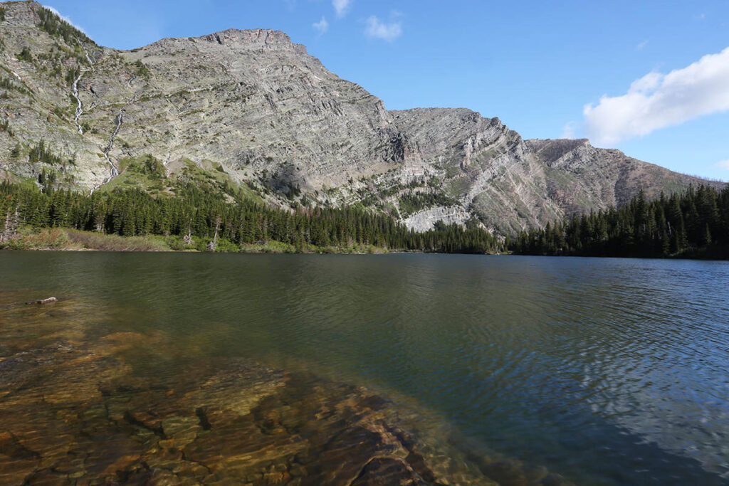
Bertha Lake.
Waterton Lakeshore Trail
Length: 14 kilometres/8.7 miles (4 hours) one-way
Elevation gain: minimal
Rating: moderate
Trailhead: south side of the town site along Evergreen Avenue
This trail follows the western shores of Upper Waterton Lake across the international boundary to Goat Haunt, Montana, linking up with more than 1,200 kilometres (746 miles) of trails in Glacier National Park.
Starting from town, the first 1.5 kilometres (0.9 mile) climb steadily through burnt forest to a lookout point high above the lake, then the hike branches left off the Bertha Lake Trail, descending to Bertha Bay. The boat dock at Boundary Bay, six kilometres (3.7 miles) from town, is a good place for lunch, or for day hikers to turn around (allow 4 hours for the roundtrip to this point). Hikers heading south and planning to enter Glacier National Park should check current US entry requirements with US Customs and Border Protection.
2023 update: Prior to 2019, hikers could take the Waterton Shoreline Cruise Co. MV International (403/859-2362) one way and hike the other, but as of 2023 this tour boat is still not stopping at Goat Haunt, so while you can still visit the south end of the lake by boat, there is no opportunity to alight and walk this trail back to town.
Crypt Lake Trail
Length: 8.7 kilometres/5.4 miles (3 to 4 hours) one-way
Elevation gain: 680 metres/2,230 feet
Rating: difficult
Trailhead: Crypt Landing; access is by boat. The Crypt Lake Shuttle (403/859-2362, June to Sept.) leaves the marina at 9 a.m. and 10 a.m. daily for Crypt Landing; return trips depart at 4 p.m. and 5:30 p.m.
The Crypt Lake Trail is one of the most spectacular day hikes in Canada. Access to the trailhead on the eastern side of Upper Waterton Lake is by boat. The trail switchbacks for 2.5 kilometres (1.6 miles) past a series of waterfalls and continues steeply up to a small green lake before reaching a campground. The final ascent to Crypt Lake from the campground causes the most problems, especially for those who suffer from claustrophobia or acrophobia. A ladder on the cliff face leads into a natural tunnel that you must crawl through on your hands and knees. The next part of the trail is along a narrow precipice with a cable for support. The lake at the end of the trail, nestled in a hanging valley, is no disappointment. Its dark green waters are rarely free of floating ice, and the steep walls of the cirque rise more than 500 metres (1,640 feet) above the lake on three sides. The international boundary is at the southern end of the lake. A good way to avoid the crowds on this trail is to camp at the dock and set out before the first boat arrives in the morning.
Crandell Lake Trail
Length: 2.4 kilometres/1.5 miles (40 minutes) one-way
Elevation gain: 120 metres/395 feet
Rating: easy
Trailhead: Crandell Campground, Red Rock Canyon Parkway
This easy hike to a subalpine lake is popular with campers staying at Crandell Campground. Alternatively, the trailhead can be reached by noncampers along the Canyon Church Camp access road. The lake can also be accessed from a trailhead seven kilometres (4.3 miles) west of town along the Akamina Parkway. This trail is shorter (0.8 km/0.5 mile) and follows a wagon road that was cut through the valley to Oil City.
Goat Lake Trail
Length: 6.7 kilometres/4.2 miles (2 hours) one-way
Elevation gain: 500 metres/1,640 feet
Rating: moderate
Trailhead: end of Red Rock Canyon Parkway, 18 kilometres (11.2 miles) from Waterton townsite
The first hour of walking from the trailhead at Red Rock Canyon follows the Snowshoe Trail along Bauerman Creek before branching to the right and climbing switchbacks through a mixed forest. The steep gradient evens out as the trail enters the Goat Lake cirque. After the uphill slog, the lake is a welcome sight, its emerald green waters reflecting the towering headwalls that surround it. Look for the lake’s namesake on the open scree slopes west of the lake.
Carthew-Alderson Trail
Length: 20 kilometres/12.4 miles (6 to 7 hours) one-way
Elevation gain: 650 metres/2,130 feet
Rating: difficult
Trailhead: end of Akamina Parkway, 16 kilometres (10 miles) from Waterton town site
This hike linking the end of the Akamina Parkway to Waterton townsite can be completed in one long day or done with an overnight stop at Alderson Lake, 13 kilometres (eight miles) from the trailhead. The trail leads through most of the climatic zones of Waterton Lakes National Park and offers some of the best scenery to be had on any one hike. Transportation aboard the Cameron Express to the trailhead can be arranged through Tamarack Outdoor Outfitters (214 Mount View Rd., 403/859-2378), which operates a hiker shuttle service to this and other trailheads in Waterton Lakes National Park.
From the Cameron Lake parking lot, the trail climbs four kilometres (2.5 miles) to Summit Lake, a worthy destination in itself. The trail then forks to the left and climbs steeply to Carthew Ridge. After rising above the tree line and crossing a scree slope, the trail reaches its highest elevation of 2,310 metres (7,580 feet) at Carthew Summit. The views from here are spectacular, even more so if you scramble up to one of Mount Carthew’s lower peaks. To the north is a hint of prairie, to the southeast the magnificent bowl-shaped cirque around Cameron Lake. To the south, the Carthew Lakes lie directly below, while glaciated peaks in Montana line the horizon. From this summit, the trail descends steeply to the Carthew Lakes, reenters the subalpine forest, and emerges at Alderson Lake, which is nestled under the headwalls of Mount Alderson. The trail then descends through the Carthew Creek Valley and finishes at Cameron Falls in the town site.
Vimy Peak Trail
Length: 12 kilometres/7.5 miles (5 hours) one-way
Elevation gain: 825 metres/2,700 feet
Rating: difficult
Trailhead: Chief Mountain International Highway, 0.5 kilometre (0.3 mile) from the Highway 5 junction
Vimy Peak overlooks the town site from across Upper Waterton Lake. It was once part of a ridge that extended across the Waterton Valley and was worn down by the relentless forces of glacial action. The initial six-kilometre (3.7-mile) stretch is along the eastern bank of Lower Waterton Lake through forest and grassland. The trail then continues along the lake to Bosporus Landing opposite the town or climbs steeply to Vimy Peak (2,379 metres/7,805 feet). The Vimy Peak Trail actually ends at a basin short of the summit, which is still a painfully steep 40-minute scramble away.