Lake Louise Hiking
The variety of hiking opportunities in the vicinity of Lake Louise and Moraine Lake is surely equal to any area on the face of the earth. The region’s potential for outdoor recreation was first realized in the late 1800s, and it soon became the centre of hiking activity in the Canadian Rockies. This popularity continues today; trails here are among the most heavily used in Banff National Park.
Hiking is best early or late in the short summer season. Head out early in the morning to miss the strollers, high heels, dogs, and bear bells that you’ll surely encounter during the busiest periods.
The two main trailheads are Fairmont Chateau Lake Louise and Moraine Lake. Two trails lead from the village to the chateau (a pleasant alternative to driving the steep and busy Lake Louise Drive). The shortest is the 2.7-kilometre/1.7-mile Louise Creek Trail. It begins on the downstream side of the point where Lake Louise Drive crosses the Bow River, crosses Louise Creek three times, and ends at the Lake Louise parking lot. The other trail, Tramline, is 4.5 kilometres (2.8 miles) longer but not as steep. It begins behind the railway station and follows the route of a narrow-gauge railway that once transported guests from the CPR line to Chateau Lake Louise.
Canadian Rockies Trail Guide.
To make your Lake Louise hiking more enjoyable, purchase a copy of the Lake Louise Hiking Guide by Summerthought Publishing. If you are spending time elsewhere in the Canadian Rockies, consider the Canadian Rockies Trail Guide by the same authors. Also recommended is Gem Trek’s Lake Louise & Yoho Map, a waterproof hiking map showing every trail in the region, as well as trail descriptions. These books and map can be purchased in advance directly from the publishers using the links above, or from the Lake Louise Visitor Centre, from The Viewpoint in the village, and Mountain Lights bookstore or Chateau Mountain Sports at the Fairmont Chateau Lake Louise.
Lake Louise and Moraine Lake Shuttles
The best way for hikers to reach Lake Louise and Moraine Lake is by shuttle from the Lake Louise Ski Resort or Banff. For more information see the Lake Louise Shuttles and Getting to Moraine Lake pages.
Bow River Loop
Length: 7 kilometres/4.3 miles (1.5 to 2 hours)
Elevation gain: minimal
Rating: easy
Trailheads: various points throughout Lake Louise Village, including behind Samson Mall
This loop follows both banks of the Bow River southeast from the railway station. Used by joggers and cyclists to access various points in the village, the trail also links the station to the Lake Louise Alpine Centre, Post Hotel, Samson Mall, both campgrounds, and the Louise Creek and Tramline trails to Lake Louise. Interpretive signs along its length provide information on the Bow River ecosystem.
Louise Lakeshore Trail
Length: 2 kilometres/1.2 miles (30 minutes) one-way
Elevation gain: none
Rating: easy
Trailhead: Lake Louise, 4 kilometres (2.5 miles) from TransCanada Highway
Probably the busiest trail in the Canadian Rockies, this one follows the north shore of Lake Louise from in front of the chateau to the west end of the lake. Here numerous braided glacial streams empty their silt-filled waters into Lake Louise. Along the trail’s length are benches for sitting and pondering what English mountaineer James Outram once described as “a gem of composition and of colouring perhaps unrivalled anywhere.”
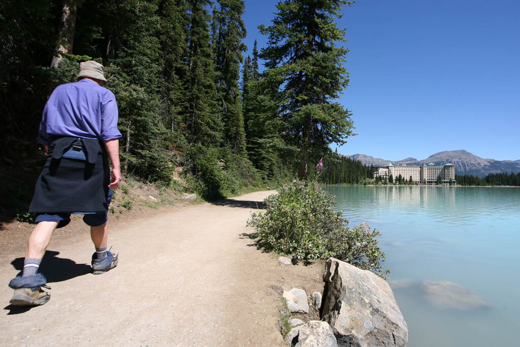
Louise Lakeshore Trail.
Plain of the Six Glaciers Trail
Length: 5.3 kilometres/3.3 miles (90 minutes) one-way
Elevation gain: 370 metres/1,215 feet
Rating: moderate
Trailhead: Lake Louise
Hikers along this trail are rewarded not only with panoramic views of the glaciated peaks of the main range but also with a rustic trail’s-end PLAIN OF THE SIX GLACIERS TEAHOUSE serving homemade goodies baked on a wooden stove. For the first two kilometres (1.2 miles), the trail follows Louise Lakeshore Trail to the western end of the lake. From there it begins a steady climb through a forest of spruce and subalpine fir. It enters an open area where an avalanche has come tumbling down (now a colourful carpet of wildflowers), then passes through a forested area into a vast wasteland of moraines produced by the advance and retreat of Victoria Glacier. Views of surrounding peaks continue to improve until the trail enters a stunted forest. After switchbacking up through this forest, the trail arrives at the teahouse. Built by the CPR at the turn of the 20th century, the teahouse operates the same way now as it did then. Supplies are packed in by horse, and all cooking is done in a rustic kitchen. It’s open from July through early September. After resting, continue one kilometre (0.6 mile) to the end of the trail on the narrow top of a lateral moraine. From here the trail’s namesakes are visible. From left to right the glaciers are Aberdeen, Upper Lefroy, Lower Lefroy, Upper Victoria, Lower Victoria, and Pope’s. Between Mount Lefroy (3,441 metres/11,290 feet) and Mount Victoria (3,459 metres/11,350 feet) is Abbot Pass, where it’s possible to make out Abbot Hut on the skyline. When constructed in 1922, this stone structure was the highest building in Canada. The pass and hut are named for Phillip Abbot, who died attempting to climb Mount Lefroy in 1896.
Lake Agnes Trail
Length: 3.6 kilometres/2.2 miles (90 minutes) one-way
Elevation gain: 400 metres/1,312 feet
Rating: moderate
Trailhead: Lake Louise
This moderately strenuous hike is one of Banff National Park’s most popular. It begins in front of the chateau, branching right near the beginning of the Louise Lakeshore Trail. For the first 2.5 kilometres (1.6 miles), the trail climbs steeply, switchbacking through a forest of subalpine fir and Engelmann spruce, crossing a horse trail, passing a lookout, and levelling out at tiny Mirror Lake. Here the old, traditional trail veers right (use it if the ground is wet or snowy), while a more direct route veers left to the Plain of the Six Glaciers. The final elevation gain along both trails is made easier by a flight of steps beside Bridal Veil Falls. The trail ends beside LAKE AGNES TEAHOUSE, which overlooks Lake Agnes, a subalpine lake nestled in a hanging valley. The teahouse offers homemade soups, healthy sandwiches, and a wide assortment of teas. From the teahouse, a one-kilometre (0.6-mile) trail leads to Little Beehive and impressive views of the Bow Valley. Another trail leads around the northern shore of Lake Agnes, climbing to Big Beehive or joining to the Plain of the Six Glaciers Trail, just 3.2 kilometres (two miles) from the chateau and 2.1 kilometres (1.3 miles) from the teahouse at the end of that trail.
Big Beehive Trail
Length: 5 kilometres/3.1 miles (2 hours) one-way
Elevation gain: 520 metres/1,710 feet
Rating: moderate
Trailhead: Lake Louise
The lookout atop the larger of the two “beehives” is one of the best places to admire the uniquely coloured waters of Lake Louise, more than 500 metres (1,640 feet) directly below. The various trails to the summit have one thing in common—all are steep. But the rewards are worth every drop of sweat along the way. The most popular route follows the Lake Agnes Trail for the first 3.6 kilometres (2.2 miles) to Lake Agnes. From Lake Agnes Teahouse, a trail leads to the western end of the lake, then switchbacks steeply up an exposed north-facing ridge. At the crest of the ridge, the trail forks. To the right it descends to the Plain of the Six Glaciers Trail; to the left, it continues 300 metres (0.2 mile) to a log gazebo. This trail is not well defined, but scrambling through the large boulders is easy. Across Lake Louise is Fairview Mountain (2,745 metres/9,000 feet), and behind this peak is the distinctive shape of Mount Temple (3,549 metres/11,645 feet). Views also extend up the lake to Mount Lefroy and northeast to Lake Louise winter resort. Views from the edge of the cliff are spectacular, but be very careful—it’s a long, long way down. By returning down the Lake Louise side of the Big Beehive, the loop is 11.5 kilometres (7.1 miles).
Saddleback Trail
Length: 3.7 kilometres/2.3 miles (90 minutes) one-way
Elevation gain: 600 metres/1,970 feet
Rating: moderate/difficult
Trailhead: boathouse, Lake Louise
This trail climbs the lower slopes of Fairview Mountain from beside the boathouse on Lake Louise, ending in an alpine meadow with a view of Mount Temple from across Paradise Valley. Four hundred metres (0.2 mile) from the trailhead, the trail forks. Keep left and follow the steep switchbacks through a forest of Englemann spruce and subalpine fir until reaching the flower-filled meadow. The meadow is actually a pass between Fairview Mountain (to the northwest) and Saddle Mountain (to the southeast). Although most hikers are content with the awesome views from the pass and return along the same trail, it is possible to continue to the summit of Fairview (2,745 metres/9,000 feet), a further climb of 400 vertical metres (1,310 vertical feet). The barely discernible, switchbacking trail to the summit begins near a stand of larch trees above the crest of Saddleback. As you would expect, the view from the top is stupendous; Lake Louise is more than one kilometre (0.6 mile) directly below. This option is for strong, experienced hikers only. From the Saddleback, the trail descends into Sheol Valley, then into Paradise Valley. The entire loop would be 15 kilometres (9.3 miles).
Paradise Valley Trail
Length: 9 kilometres/5.6 miles (3 hours) one way
Elevation gain: 380 metres/1,250 feet
Rating: moderate
Trailhead: Moraine Lake Road, 3.5 kilometres (2.2 miles) from Lake Louise Drive
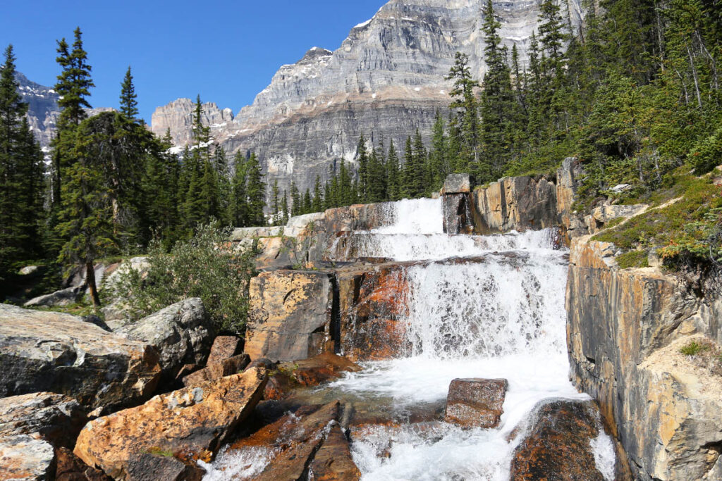
This aptly named trail makes for a long day hike, but it can be broken up by overnighting at the backcountry campground at the far end of the loop. The trail climbs steadily for the first five kilometres (3.1 miles), crossing Paradise Creek numerous times and passing the junction of a trail that climbs the Sheol Valley to Saddleback. After five kilometres (3.1 miles) the trail divides again, following either side of the valley to form a 13-kilometre (eight-mile) loop. Lake Annette is 700 metres (0.4 mile) along the left fork. It’s a typical subalpine lake in a unique setting—nestled against the near-vertical 1,200-metre (3,940-foot) north face of snow- and ice-capped Mount Temple (3,549 metres/11,645 feet), one of the 10 highest peaks in the Canadian Rockies. This difficult face was successfully climbed in 1966, relatively late for mountaineering firsts. The lake is a worthy destination in itself. Allow yourself four hours round-trip from the trailhead.
Continue beyond Lake Annette into an open avalanche area that affords views across Paradise Valley. Look and listen for pikas and marmots among the boulders. The trail then descends and crosses Paradise Creek, and you’ll quickly arrive at a series of waterfalls known as the GIANT STEPS.
For information on reaching the Paradise Valley trailhead, see Getting to Moraine Lake.
Larch Valley Trail
Length: 2.9 kilometres/1.8 miles (60 minutes) one-way
Elevation gain: 400 metres/1,310 feet
Rating: moderate
Trailhead: Moraine Lake, 13 kilometres (8 miles) from Lake Louise Drive
In fall, when the larch trees have turned a magnificent gold and the sun is shining, few spots in the Canadian Rockies can match the beauty of this valley, but don’t expect to find much solitude. Although the most popular time for visiting the valley is fall, it is a worthy destination all summer, when the open meadows are filled with colourful wildflowers. The trail begins just past Moraine Lake Lodge and climbs fairly steeply, with occasional glimpses of Moraine Lake below. After reaching the junction of the Eiffel Lake Trail, veer right, passing through an open forest of larch and into the meadow beyond. The range of larch is restricted within Banff National Park, and this is one of the easiest accessible areas where they are prolific. The trail climbs through larch forest for another kilometre or so to the Minnestimma Lakes.
For information on reaching the Larch Valley trailhead, see Getting to Moraine Lake.
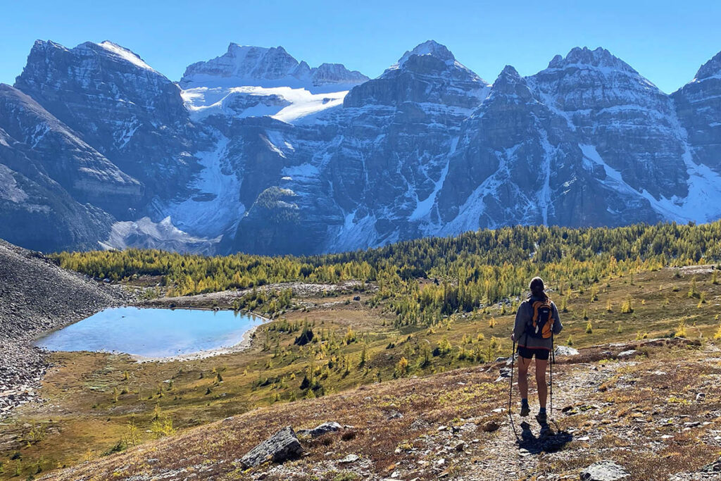
Larch Valley.
Sentinel Pass Trail
Length: 5.8 kilometres/3.6 miles (2 to 3 hours) one-way
Elevation gain: 725 metres/2,380 feet
Rating: moderate/difficult
Trailhead: Moraine Lake
Keen hikers should consider continuing through the open meadows of Larch Valley (see above) to Sentinel Pass (2,608 metres/8,560 feet), one of Banff National Park’s highest trail-accessible passes. The length and elevation gain listed are from Moraine Lake. Once in Larch Valley, you’re halfway there and have made over half of the elevation gain. Upon reaching Larch Valley, take the formed trail that winds through the open meadow. After climbing steadily beyond Minnestimma Lakes, the trail switchbacks for 1.2 kilometres (0.7 mile) up a steep scree slope to the pass, sandwiched between Pinnacle Mountain (3,067 metres/10,060 feet) and Mount Temple (3,549 metres/11,645 feet). From the pass most hikers opt to return along the same trail, although with advanced planning it is possible to continue into Paradise Valley and back to the Moraine Lake access road, a total of 17 kilometres (10.6 miles) one-way.
Eiffel Lake Hiking Trail
Length: 5.6 kilometres/3.5 miles (2 hours) one-way
Elevation gain: 400 metres/1,310 feet
Rating: moderate
Trailhead: Moraine Lake
Eiffel Lake is small, and it looks even smaller in its rugged and desolate setting, surrounded by the famed Valley of the Ten Peaks. For the first 2.4 kilometres (1.5 miles), follow the Larch Valley Trail, then fork left. Most of the elevation gain has already been made, and the trail remains relatively level before emerging onto an open slope from where each of the 10 peaks can be seen, along with Moraine Lake far below. From left to right the peaks are Fay, Little, Bowlen, Perren, Septa, Allen, Tuzo, Deltaform, Neptuak, and Wenkchemna. The final two peaks are divided by Wenkchemna Pass (2,605 metres/8,550 feet), a further four kilometres (2.5 miles) and 360 vertical metres (1,180 vertical feet) above Eiffel Lake. The lake itself soon comes into view. It lies in a depression formed by a rockslide from Neptuak Mountain. The lake is named for Eiffel Peak (3,085 metres/10,120 feet), a rock pinnacle behind it, which with a little imagination could be compared to the Eiffel Tower in Paris.
For information on reaching the Eiffel Lake trailhead, see Getting to Moraine Lake.
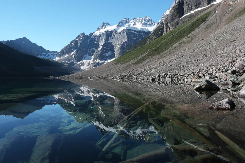
Consolation Lakes Trail
Length: 3 kilometres/1.9 miles (1 hour) one-way
Elevation gain: 65 metres/213 feet
Rating: easy
Trailhead: beside the restrooms at Moraine Lake parking lot
This short trail begins with a crossing of Moraine Creek at the outlet of Moraine Lake and ends at a pleasant subalpine lake. The first section of the trail traverses a boulder-strewn rock pile—the result of rockslides on the imposing Tower of Babel (3,100 metres/10,170 feet)—before entering a dense forest of Engelmann spruce and subalpine fir and following Babel Creek to the lower lake. The wide valley affords 360-degree views of the surrounding jagged peaks, including Mount Temple back down the valley and Mounts Bident and Quadra at the far end of the lakes.
For information on reaching the Consolation Lakes trailhead, see Getting to Moraine Lake.